This layer shows the percentage of children under 6 months who are exclusively breastfed, meaning they receive only breast milk without any additional food or drink. Exclusive breastfeeding is a key d...
This layer provides estimates of the percentage of children aged 2 to 10 years (PfPR2–10) with detectable Plasmodium falciparum parasites in 2022. The estimates are generated using geostatistical mode...
This layer represents the estimated travel time (in hours) by foot to the nearest primary school. The accessibility map is generated using a well-established geospatial methodology that integrates roa...
The Armed Conflict Location & Event Data Project (ACLED) dataset is a disaggregated conflict event dataset designed for real-time monitoring and analysis. It records the specific dates, locations, act...
The dataset depicts the total energy demand per settlement (kWh/day) at year 5 under scenario with household consumption raised to 1000 Wh/day (at year 0). This dataset is part of the e Refugee Settle...
Percentage of children in a school attendance age (approximately 3-17 years old depending on the country) that have internet connection at home. Also in this case the indicator relates to the potentia...
Adult literacy rate is the percentage of people ages 15 and above who can both read and write with understanding a short simple statement about their everyday life. Literacy statistics for most countr...
Percentage of children aged 6-8 that currently attends, or in the current school year attended, school. This indicator measures the potential educational impact of bringing electricity to schools; the...
The Rule of Law Index, generated by the World Justice Project, illustrates the perceived adherence to the Rule of Law per country. Rule of law is defined here as a durable system of laws, institutions...
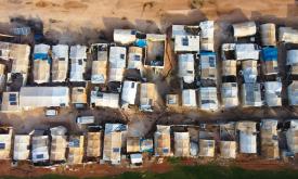
The GHS-BUILT-V R2023A dataset depicts the distribution of built-up volumes, expressed as number of cubic meters. This data reports about the total built-up volume. Data are spatial-temporal interpola...
The GHS Settlement Model layers (GHS-SMOD) GHS-SMOD_GLOBE_R2023A delineate and classify settlement typologies via a logic of cell clusters population size, population and built-up area densities as de...
The GHS Settlement Model layers (GHS-SMOD) GHS-SMOD_GLOBE_R2023A delineate and classify settlement typologies via a logic of cell clusters population size, population and built-up area densities as de...
The GHS Settlement Model layers (GHS-SMOD) GHS-SMOD_GLOBE_R2023A delineate and classify settlement typologies via a logic of cell clusters population size, population and built-up area densities as de...
The GHS Settlement Model layers (GHS-SMOD) GHS-SMOD_GLOBE_R2023A delineate and classify settlement typologies via a logic of cell clusters population size, population and built-up area densities as de...
The GHS Settlement Model layers (GHS-SMOD) GHS-SMOD_GLOBE_R2023A delineate and classify settlement typologies via a logic of cell clusters population size, population and built-up area densities as de...